Sloatsburg Historical Society
Sloatsburg is a village rich in history and proud to share it.
Come and take a step back in time....
About the organization: Since 1979 the Sloatsburg Historical Society has been actively promoting the awareness of local history through slide presentations, speaker programs, and by publishing two books. The society also accumulates and maintains a collection of documents and artifacts in conjunction with the Sloatsburg Public Library. The society also conducts an annual educational program for 4th grade students at the Sloatsburg Elementary School. The society responds to queries regarding structures, sites, events, and genealogy. It actively pursues restoration and preservation of key local historical sites, as well as nominating sites for listing on the National Registry of Historic Places.
Historic Sloatsburg
This area was first inhabited by the Leni-Lenape Indians. An archaeological excavation of an Indian shelter in Sloatsburg disclosed artifacts dating back over 5,000 years. (See display at the Sloatsburg Library).
In 1738 Dutch settler, Wynant Van Gelder purchased a tract of land called Pothat from the local Indians - that tract was to become the village of Sloatsburg. In 1747 Van Gelder deeded the land to his brother-in-law, Isaac Van Duzer (Van Deursen). Van Duzer in turn deeded the property in 1763 to his son-in-law, Stephen Sloat. At that time, there was no inland route for wagon travel upstate to Albany and other northern settlements. Dutch settlers like Isaac Van Duzer, Stephen Sloat and others recognized that an old Indian trail through the Ramapo Pass could be widened and leveled to form such a route. They began this work and also expanded their homes into inns to accommodate the travelers along this roadway. The old Sloat home & Inn at the entrance to Sloatsburg has been preserved and is listed on the National Register of Historic Places.
This route was fully opened for wagon traffic at about the time of the start of the Revolutionary War. The British had conquered New York City and were intent upon seizing Albany. General Washington blocked their access on the Hudson River with a huge chain stretched across the river and gun emplacements at West Point. To block the inland route at the Ramapo Pass, he established a command post at the Sloat home and placed Captain Stephen Sloat in charge of the troops guarding the Pass. Stephen's eldest son, Private John Sloat was subsequently shot by a sentry and buried on a grass knoll that later became the Sloat Family burial plot and eventually the Sloatsburg Cemetery - also listed on the National Register of Historic Places.
Isaac Sloat, son of pioneer Stephen and brother of Pvt. John was the first entrepreneur of this area. By 1792 he had constructed a dam across the Ramapo river with a system of sluice gates and a mill race to provide water power to run a saw mill and tannery located in what is now downtown Sloatsburg. Jacob Sloat, a son of Isaac, constructed a cotton mill in 1815. His operation was so successful that it was enlarged several times and continued to be a major local employer until destroyed by fire in 1955. It was Jacob Sloat and his industry that put Sloatsburg on the map, becoming an incorporated village in 1929.
In 1800, the Orange Turnpike Association was formed and until the NYS Thruway was completed in 1957, the Orange Turnpike - now Route 17 - was the only major route to upstate New York. Thousand of passengers passed through "Downtown Sloatsburg" annually. The Glenwood Inn, Taylor's Inn and the Henry Inn were elegant restaurants and hotels catering to those travelers in the early 1900's. Commerce flourished in "Downtown Sloatsburg" during that period. Multiple grocery stores, gasoline stations, departments stores, and many other stores and services lined "Main Street Sloatsburg" until after World War II when the concept of shopping malls and other social changes negatively impacted shopping in local villages. Sloatsburg is now primarily a remote and environmentally attractive residential area for commuters who work in other areas.
Glenwood Hotel
1999 Historic Preservation Merit Award Winner
Presently: Character's Restaurant & Lounge
Originally: The Glenwood Hotel
The Glenwood Hotel is an historic landmark in the Village of Sloatsburg, NY. In 1998, new owners, Mr. & Mrs. DeMatteis made needed structural repairs while preserving the original structure and restoring the original appearance of the Glenwood Hotel of the early 1900's. In December of 1998, the restored building was reopened as the Aldente Italian American Restaurant.
The Village of Sloatsburg has a rich historical heritage. A number of early sites and structures still exist but many are in need of restoration. The efforts of the Mr. and Mrs. DeMatteis in restoring one of the Village's oldest buildings, the historic Glenwood Hotel, for adaptive use as an haute-cuisine restaurant sets an excellent example and theme for encouraging further restoration activities in the Village.
HISTORY & CHRONOLOGY:
Tax records of the late 1800's identify this property as containing three buildings. One small building behind the present restaurant, was to serve in the early 1900's as ice house for the Glenwood hotel. A second, located in what is now the parking lot, served in the early 1900's as the Barber shop of Louis D'Avanzo then during the mid 1900's as the Boland Market. This dilapidated old building was razed in 1974. The third and largest building served in the late 1800's as a rooming house and was to became the Glenwood Hotel. Henry Tobin purchased the property in 1903. In 1906 Tobin's Saloon is listed in the Erie RR Directory for Sloatsburg and in 1908 the Glenwood Hotel is first listed. The first floor was remodeled to serve as a restaurant offering open-air dining on the large veranda style porch in addition to an elegant main dining room.. The upper floors continued to be operated as boarding rooms, primarily for workers in the mills of Sloatsburg until around 1950. The Glenwood Hotel was owned and operated by Henry and Kathleen Tobin.
Until the NYS Thruway opened in 1957, the Orange Turnpike (Route 17) was the only major highway for travelers from NYC, Rockland county and New Jersey to drive to upstate New York, Vermont and Canada. The elegant dining rooms of the Glenwood Hotel, located directly on the Orange Turnpike, became a favorite dinner stop for many travelers. This was also during the most active and years of nearby Tuxedo Park and those wealthy patrons were reported to be regulars at the Glenwood as well. It is even rumored that during prohibition years (1920-1933), the Glenwood offered its patrons other incentives as well. Before prohibition, there was a workingman's bar in the rear but Mr. Tobin stood guard to ensure that no-one without a jacket and tie entered the dining room.
The Glenwood Hotel flourished as a restaurant for fine dining for nearly fifty years - until the opening of the NYS Thruway diverted travelers away from the Orange Turnpike. That, plus a diminishing of the super-rich era in Tuxedo Park, significantly reduced the traditional clientele for a first class restaurant.
Sometime after the death of Mr. Tobin (1928), a sister of Kathleen Tobin, Mrs. Williams recently widowed, came with her two children, Claire and Kerwin Williams, to live with Mrs. Tobin. After Mrs. Tobin's death (1948) Claire and Kerwin lived in the upstairs of the building and continued the operation of the restaurant as the Glenwood Inn until around 1970.
The Henry Club
Presently: Valley Rock Mountain Market
Originally: The Henry Club
Originally called the Association Hall, this three story building was constructed in 1911 by the 180 member Carpenter's Union, the Mason's Union and the Painter's Union. The third floor served as the Union Hall for many years to come.
In 1914, The Henry Club was conceived and made possible by Mrs. Alfred Loomis of Tuxedo Park. It was named in memory of her son who died young. The Henry Club comprised primarily the second floor which was remodeled, equipped and furnished by Mrs. Loomis and boasted a modern gas lighting system donated by a local businessman. The Club was controlled by a local board of directors for use by all residents and served as Sloatsburg's community center from 1914 through 1942.
The large second floor served many functions, including:
Movie Theater/Dance Floor/Theatrical State/Auditorium/Gymnasium/Kitchen/Library and Reading Room/Card and Billiard Room.
Its activities included:
Dime Movies/Bingo Games/Saturday Night Dances/Plays and Concerts/Dance Classes/Community Meetings/Christmas and Halloween Parties/Labor Day Picnics and Clam Bakes
A local band, Glee Club and Dramatic Club performed here regularly. There were stairs behind the state leading up to dressing rooms on the third floor.
Sloatsburg School graduations were held here for many years.
Catholic services were held in the Henry Club for a period prior to the completion of St. Joan of Arc Church in 1924.
Civic groups organized at the Henry Club and who held their early meetings and ceremonies in this building included:
Sloatsburg Daughters of America (1914)
Sloatsburg Boy Scouts (1916)
Sloatsburg Girl Scouts (1919)
Sloatsburg Volunteer Fire Department (1923)
Jacob Sloat House

Written by Peter Bush
"Harmony Hall", original home of Jacob Sloat, built 1848. A considerable example of late Greek Revival style. Typified by raised center section and flanking symmetrical wings, with verandah carried by squared piers or classical antae. Built on a knoll in the town center of Sloatsburg, NY, the grounds included a long entrance drive with fountain and garden ornaments in the manner of design suggested by the influence of horticulturist, Andrew Jackson Downing.
Jacob was a mechanical genius and held the third patent granted by the U.S.A. in 1813. In addition, Jacob was the owner and operator of a mill for the manufacture of cotton cloth and later twine in connection with stocks and dies, in which latter articles Jacob Sloat was soon to lead the New York market.
The mill provided an economic anchor for the village of Sloatsburg, providing jobs and resulting in a vital commercial main street that included sundry shops, eating establishments and three houses of worship.
In the 20th Century "Harmony Hall" became an elegant restaurant and later a rest home for women. Harmony Hall has recently been purchased by the Town of Ramapo under their open space program. A committee has been established to preserve, restore and oversee the operation of Harmony Hall. The Chairperson of this Committee is Mr. Harrison O. Bush.
Old Cemetery
Written by Eugene Kuykendall
The Sloatsburg Cemetery dates back over 200 years to when Pvt. John Sloat was buried on a "grassy knoll' in 1781 (His hand carved fieldstone may be viewed today in the Sloat Family Plot).
By 1832, this had become the Sloat family burial plot. Jacob and Stephen Sloat, the industrialists and founding fathers of Sloatsburg, are buried here as are their children and grandchildren.
By 1852, other local families began burials in what is now known as the "hill section" of the cemetery.
In 1878 a Sloatsburg Cemetery Association was formed. From 1878-1936 this Association acquired property, sold and maintained family burial plots.
Nearly 1,200 individual headstone inscriptions are to be found today in this approximately 5 acre cemetery, including veterans of all major wars. Perhaps half that many again are known to be buried there without headstones. It remains an active cemetery where a few people still own burial lots. The names on the headstones present a virtual history of the families who founded and populated Sloatsburg.
Since 1936, this cemetery, like many other older burial grounds, has been effectively un-owned, unmanaged, ill-maintained and un-cataloged. Some families continue to provide care for individual family plots, but much of the grounds have become badly overgrown over the years despite several ad-hoc cleanup efforts and unsuccessful attempts to provide for continuing care. Headstones have become weather stained, sunken, fallen and broken, some vandalism has occurred, and other restoration actions are needed.
The Sloatsburg cemetery is one of the most significant historic sites in Sloatsburg, and, more importantly, the final resting place for many of the early local families. It is located in a secluded wooded area of the village with a stream running nearby. It is in the process of being restored and maintained as an attractive point of pride for our community.
John Sloat's Burial Plot

Sloatsburg Cemetery. Entrance from Eagle Valley Road one block west of Route 17. Sloat Family lot located at far east end of cemetery. Arrow points to first burial - John Sloat, April 17,1781.
The Sloats House & Inn
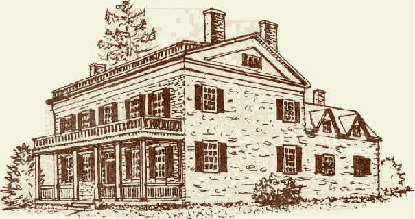
Etching of restored Sloat home and tavern dating back as early as 1745. Located at southern entrance to Sloatsburg on west side of Route 17. Current home of Village Clerk & Treasurer, Thomas Bollatto, Jr.
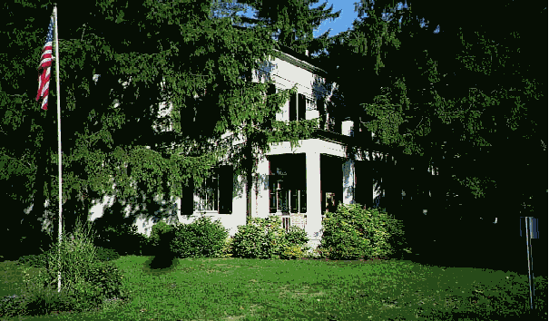
Current photo
Description Excerpted from National Registry
(listed 1976)
The history of this house may go back to Wynant Van Gelder in 1738, or Isaac Van Deusen (bapt. Feb. 6, 1698) in 1747, when they respectively owned and lived on this land-the first white settlers in this part of the Clove. The rear wing, now mainly kitchen, gives the appearance of being very early and primitive.
Stephen Slot (1727-1808) came from Hackensack and married Martha Van Dusen (Marritje 1727-1807) about 1753. Stephen's great grandfather was Jan Pietersen (Peter) Slot who came from Holstein, Holland before 1662 and settled at Corlear's Hook. This tract in Pothat (now Sloatsburg, named for Stephen and his descendants) was conveyed as a gift to Martha and Stephen by her father, Isaac Van Dusen (Deusen), on June 3, 1763. Stephen and Martha had: John in 1754, who became a captain in the Cornwall Militia in the Revolution and was accidentally and fatally shot by one of their own sentries in the doorway of the Sloat House (bullet marks exist); Isaac (1758-1821) who inherited the house; Elizabeth, born in 1761; and Maria, born in 1767.
Captain John's son, Rear Admiral John Drake Sloat (1781-1867) had a brilliant naval career. As Commodore, his most famous feat was the capture from Mexico and claiming of the territory of California for the United States on July 7, 1846 before the British could do so. Ironically, his namesake and ancestor, Sir. Francis Drake, had accomplished the same feat for England in 1579. A monument to Commander-in-Chief Sloat remains at Monterey, California.
Stephen either built or enlarged this house in 1755. Indications in the structure lead one to believe that a frame section, in addition to the old part stone wing, existed at the time of the Revolution, which has now been replaced. Probably the most important event in the history of the house is that, according to Willard Deyoe (writer), General George Washington stayed here on Sunday, June 5, 1779, and may have stopped here previously as he frequently used the road through the Clove.
Stephen's son Isaac married Lea Zabriskie about 1779, built a tannery in 1792 and probably built the main front part of the house in 1813-14. Isaac ran it as a public house and it was the annual meeting place of "Supervisors, and Judges of the Court of Common Pleas of Orange and Rockland counties for 23 years (1798-1821) for the purpose of inspecting and examining the mortgages, minutes, and accounts of the loan officers appointed in the county of Orange under the act for loaning moneys belonging to the State."
Isaac's son Stephen (1789-1861) and Jacob inherited the house. Stephen married Catherine Mead Ward in 1809 and was a prominent farmer and manufacturer, building first a grist mill. He ran the house as an inn known for its good food but allowed no alcoholic drinks. It was a well-known stage stop, and the barn, with its eight stalls for the four coach horses, still exists. Brother Jacob became Major Sloat and went into manufacturing. He gave property for the Methodist Church in 1837 and built the brick railroad station. Stephen's son, William Lafayette Sloat (b. 1824), ran the mill, bought and erected stores, and bought out the other heirs to the homestead.
The Ramapo Pass
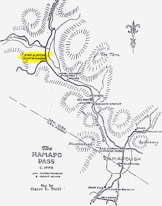
Map of the Ramapo Pass circa 1778 by Rockland county historian and cartographer, Claire Tholl.
The Sloat Dam
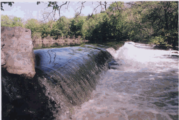
Original stone dam constructed by Sloat family circa 1792 to provide water power for mills. Reinforced with concrete in mid 1800's. Located on Ramapo River about two blocks north-east of the village hall.
Old Erie Railroad Station
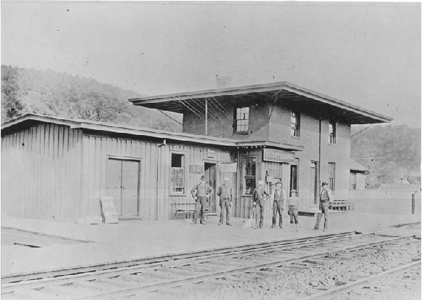
Sloatsburg Erie RR station completed in 1841. Torn down in the 1950's. Site of present commuter railroad platform.
Cappermore Farm
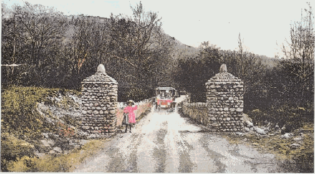
Entrance to Cappermore Farm & Brown’s Gate
By Eugene Kuykendall
The Brown's Gate leading to the main estate.
The two pillars are currently located across from the train station next to the Orange & Rockland substation.
The Brown Estate / Cappermore Farm (circa 1949 ). The estate was torn down in the 1950's to make way for the NYS Thruway.
Brown's Gate
Written by Eugene Kuykendall
The area above and below the boundary of Orange and western Rockland counties in New York, was a major site of industrial development in the late 1700's and early 1800's. There were three natural contributing factors: Rich Iron ore deposits in the area, timber from the heavily wooded hills as fuel for furnaces, and the Ramapo river to provide water power to run mills and other forms of manufacture. A fourth factor added in the early 1800's was the Orange Turnpike and the Nyack Turnpike that permitted transporting goods to the Hudson river for shipment to markets in New York City.
A common approach utilized by early entrepreneurs in utilizing the river to provide water power was to select one of the wider and deeper sections of the river, construct a dam to raise the water level creating a pond behind the dam, and build a sluice gate to regulate the flow of water from the elevated pond into a rapidly moving stream of water. This stream of water, generally referred to as mill races, would be channeled to a paddle wheel at a nearby mill operation to drive early mills, forges and other forms of manufacturing. Examples in this area include the following three:
As early as 1792, Isaac Sloat built such a system to power a saw mill and a tannery in what became the village of Sloatsburg in northeastern Rockland county. Isaac's son, Jacob Sloat, built a textile mill at that site in the early 1800's. This "Sloat Mill" was expanded over the years into a major textile factory and continued in operation until it was destroyed by fire in 1955. The dam and sluice gate were obviously rebuilt from what would have originally been a stone and wood structure to a cement structure during the mid 1800's. The "Mill Race" was filled in after a local girl drowned there, but its path and culvert under the Erie Railroad tracks remain visible. All remains of the "Sloat Mill" were razed by a potential land developer.
Around 1795, Benjamin Pierson and his sons began constructing a similar and even larger system for powering nail making and later other iron products at "Ramapo Works" now the hamlet of Ramapo just south of Sloatsburg. Ramapo Works , under the Pierson family, grew to be a major employer, many of whose employees lived in company built homes in the current hamlet of Ramapo.
Around 1800, Abraham Dater built a system for powering the first of six iron forges in an area first known as "Dater's Works". The Iron forges and subsequent grist mill and saw mill of the Dater family and the community of workers they created, became the hamlet of "Pleasant Valley" in the 1800's and, by the early 1900's, annexed to become part of the village of Sloatsburg, still known popularly as "Upper Sloatsburg".
It is interesting that only the earliest system, that of Isaac Sloat, remains virtually intact today.
Brown's Family
The following was excerpted from "Historic Sloatsburg". Gene Kuykendall. Additional Research By Janet Farrelly-Reimer and Kathy Goldman.
Nicholas T. Brown was born in New York City 3/5/1849.
Nicholas' mother: Ann Carney, a direct descendant from Cappermore Ireland, and original settler of Cappemore Farm.
His parents, Edward Brown and Ann Carney came from Cappamore, Ireland-hence the name "Cappamore Farm". Nicholas was a kind man, who originally had twelve children. Three of the children died soon after birth, but the other nine lived a very eventful life. Some of the children are still alive today.
Nicholas was an alderman (councilman) ion New York City. He also owned apartment buildings in NYC, which was how he was able to build a mansion for himself and his family-"The Brown Estate". He had bought land in Sloatsburg from a man named Theodore Hath. My great grandfather chose to locate there because of the beautiful natural surroundings.
Nicholas eventually contracted the flu, and my great-grandmother hired a nurse, Mrs. McCarthy to take care of him. The nurse stayed at the house and eventually my great-grandfather had given Mrs. McCarthy the flu as well. So then Mrs. Brown had to take care of the nurse. My great-grandfather never recovered from this and eventually died, June 20, 1917 at the age of 68. Mrs. McCarthy, however, did recover. Mrs. Brown never did catch the flu.
Nicholas T. Brown was remembered well by his children. My great-uncle Tom was just 10 years old when his father died. He remembers his dad as a "pipe smoker" who was always very good to him.
Taylors Corner
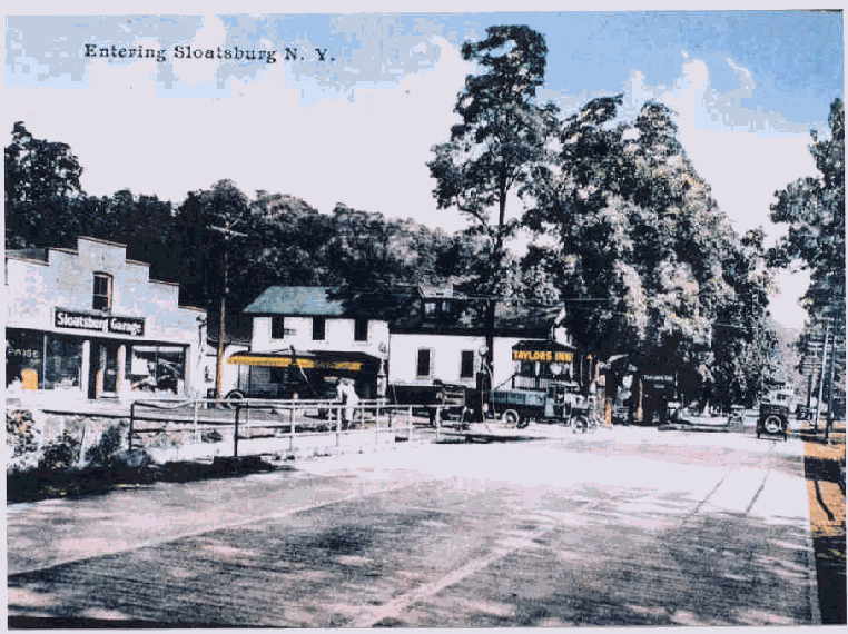
Picture circa 1929.
The entrance to Sloatsburg. Intersection of Rte 17 and Eagle Valley Road. Old Sloatsburg Garage now Sloatsburg Auto Body. Old Taylor Inn replaced by US Post Office.
Knapps's Dam
The mystery of Knapp’s Dam in Sloatsburg.
The Ramapo River provided waterpower to drive the mills and forges of early industry in Sloatsburg. We can still see today Sloat's Pond Dam, Sluice Gate and Millrace just behind the O&R sub-station. The remains of Dater's Dam can also be seen just North of Dater's Bridge.
When Sloatsburg's premier historian, Clarence Conklin, told me that Hiram Knapp also had a dam to power his Shoddy Mill (shoddy is a cheap form of cotton used for packing) that was new news-- I had never seen reference to it before. The old shoddy mill of the early 1800's was located on the site of what is now the Sterling Stone Company, just north of Seven Lakes Drive on Route 17.
I walked the river and the property trying to find some sign of an early dam or millrace. I could find no signs whatsoever of any dam foundation along the sides of the Ramapo River. There is a culvert on the grounds under the RR track, well below ground level and completely filled in. Why was there only one culvert under the RR? There should have been two, one to conduct the water to the mill and a second to return the water to the river. More importantly, the ground level immediately to the west, where the mill was located is significantly higher than the level of the river. How could water flow uphill to power the mill? Was even Clarence Conklin capable of being mistaken? I had never known that to happen before.
Shortly thereafter, Craig Long, Ramapo Town Historian, let me copy a 1916 map of Sloatsburg in the possession of Suffern Museum. Lo-and-behold, that map shows three dams within Sloatsburg, all unlabeled. Clearly one is Sloat's Dam, another to the north is Dater's Dam and the third is in the right location to be Knapp's Dam.
In the absence of Clarence who had returned to Ohio, I conferred with Fred Waldron. Fred confirmed the existence of Knapp's Dam and explained the credibility problems I had observed, i.e.:
The area west of the Ramapo River was originally at the same level as the river allowing a millrace to run from the river to the Knapp's mill. When the Orange Turnpike was widened, dirt excavated for the project was used as fill to raise the area that had been the site of Knapp's Mill.
The stone foundation of Knapp's Dam has been completely eliminated by the wear of time and floods. Fred Waldron remembers as a child seeing remains of both Dater's and Knapp's Dam in the form of large timbers piled up along the banks of the river. The larger dams of Sloat and Pierson were originally built of stone and reinforced with concrete in the mid-1800's. The smaller dams of Dater and Knapp were constructed of heavy timbers cut square and anchored to the stone foundations on the riverbanks. Those timbers have long ago rotted and been swept away during flood periods.
The culvert still visible today, was the inlet for the millrace providing power to a paddle wheel at the damp located just south of the culvert. The millrace continued to flow south to a collecting pond then back under the RR through a second culvert. Today, the return culvert is completely covered over and it's exact location unknown.
Knapp's Shoddy Mill was a major employer of Sloatsburg residents during the 1800's. A large bell at the mill sounded starting time and quitting time. That bell can still be heard every Sunday morning. It was a gift from the Knapp family to the Sloatsburg Methodist Church.